The man on the telly said this week that we all need to do more exercise, move more, and eat less because we're all getting obese. And the statistics for Central Bedfordshire also show that in Houghton Regis we're a little on the large size. So this afternoon saw me make the most of the excellent weather we're having at the moment, with a 90 minute jaunt around Tithe Farm and back home again.
I haven't walked this particular route in its entirety before, and I'm not the fastest of walkers, partly owing to the constant sciatic pain in my left leg. My right leg could walk for ever (possibly), but my left leg can't. Still, if I convince myself there is no pain and if my right leg can do it, so too can my left leg, then the walk is do-able (just about).
After leaving the skate park at Tithe Farm Recreation ground I headed north towards Grove Farm.
Part way along, this is the view west.
... and this is the view east.
... and this is the view south, looking back the way I came.
A little further north, over the brow of a slight rise, the view towards Grove Farm.
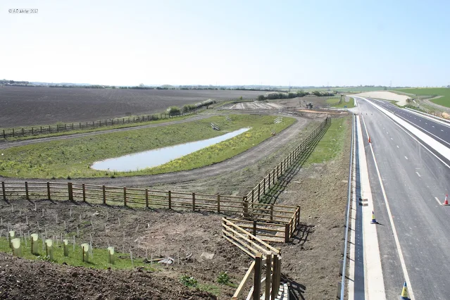
Beside the new dual carriageway, the old field paths have been diverted. The westerly view.
From the bridlepath, close to the dual carriageway, looking south back towards Tithe Farm.
The old A5 is just a few weeks away from being diverted from its present course between Hockliffe and M1 junction 9 at Flamstead, to do a sharp easterly turn near Thorn and head instead towards the M1. No longer will this ancient coaching route, outflanked by the railway era, then outflanked by the
M1 in 1959, be allowed to flow through the congested town of Dunstable.
The big hope is that once de-trunked Dunstable will no longer attract HGVs and instead they'll be banished to this picturesque part of Bedfordshire laying in a shallow chalk valley between Houghton Regis and Chalgrave Parish. The newly routed traffic will thus be able to connect to a new Junction 11a, avoiding such places as the village of Toddington, and the centre of Houghton Regis.
The new road will also become the new boundary for the Green Belt, permitting up to 5150 new homes to be built around the east and north of Houghton Regis. So, another reason for the walk, to make the most of what is there because it will soon be turned into an urban jungle of new roads, tarmacked footpaths, cars parking on footpaths, potholes, crisp packets, discarded pop bottles, dog-poo, and fly-tipped junk. As you may have gathered, I am one of those with little faith that old habits will ever go away.
From the dual carriageway bridlepath bridge, westerly view.
From the dual carriageway bridlepath bridge, easterly view towards Lord's Hill
Also from the dual carriageway bridlepath bridge, easterly view towards Lord's Hill
Followed the diverted bridlepath through Grove Farm. You may be lucky enough to see the ponies grazing. The route continues to the ancient Ede Way or Theedway route (see Theedway notes at foot of this article). Here is the view looking towards Toddington.
Time for a selfie!
View from Ede Way towards Houghton Regis.
The dual carriageway is now hidden beyond the green field.
Similar viewpoint as the previous picture, this time more inclined towards Luton.
Ede Way is quite wide as it gets closer to the M1.
Before long, a signpost and path back into Tithe Farm beckon. This old path now stops at the dual carriageway and leads you up a long slope to a new pedestrian only bridge.
View east, towards M1, from pedestrian only bridge.
View west from pedestrian only bridge.
>
Another view west from pedestrian only bridge
The long walkway to the pedestrian only bridge. Note the new channels cut in to take rain water.
This view looks back north east towards the recently completed Sundon Road bridge, marked "A" on the map above.
This view looks back north west towards the recently completed Sundon Road bridge, marked "B" on the map above.
THEEDWAY (or Ede Way)
An Anglo Saxon charter of 966 for Linslade gives evidence of a trade route for salt in Bedfordshire. It was the main east-west route through the settlement known as Thiodwegthe from where 'Theedway' or 'or Ede Way' is probably derived. This route crossed the Ousel at 'Yttingaford' (now Tiddenfoot), and moved eastwards 12 miles across Bedfordshire, Eggington, Chalgrave, and converged into the Icknield Way, north of Luton at the foot of Warden hills. The northern boundary of Luton is established along the Theedway, and has been the boundary for at least a thousand years, and is the present limit of Luton's built up area. A section of Theedway survives near Linslade as Bridleway37 near Grovebury Farm north of the A505. (ref. Greensand Trust).
This route was noted in the Chalgrave Charter of King Athelstan in AD926 (1034) and was therefore in use during the Anglo-Saxon period (Blundell J H, 1925, Toddington, Its Annals and People. E. Ashby 1925). Possibly a successor of the putative Icknield Way prehistoric route, and its name means 'the people's road or highway'. It passes through all of Bedfordshire's Royal Manors, but avoids key settlements. The route may have been used to transport salt from the East Anglian Fens inland, avoiding paying tolls at towns and markets (Edgeworth, M, 2007, Anglo-Saxon and Medieval Bedfordshire, in Oake, M et al (ed),
Bedfordshire Archaeology – Research and Archaeology: Resource Assessment, Research
Agenda and Strategy, Bedfordshire Archaeology Monograph 9, 87-109 ). The origins of the route are unclear; it has been suggested that it was a prehistoric track, as concentrations of struck flint have been along its course (Austin, W, 1928, The History of Luton and its Hamlets, Volumes 1 and 2. County Press). The route remained important into the 18th century, when it started to decline. It was finally removed as a major thoroughfare by the 19th century enclosures.


